Best of Mapping Charleston
- Kendall John
- May 30, 2025
- 5 min read
Written in collaboration with Jacob Mossbrook.
During the year, we have been processing a large collection of maps that have been previously closed for research, and we wanted to showcase our favorites. The categories are:
Oldest
Newest
Biggest
Smallest
Best Handwriting
Worst Handwriting
Most Likely to Have a Street Named for Them
Most Underrated
Most Confusing
Most Memorable
Best Use of Recycled Paper
Best Doodles
Keep scrolling to see our winners!
Oldest: 1837 Plat of Cumberland Street
Our oldest original map is believed to be this 1837 plat of Cumberland Street by Charles Parker. We have many copies of older maps in our collection, but we know they were done later because of the materials used. For example, blueprint paper was invented in the 1840s, while drafting film was invented in the 1950s. This map is on linen-backed paper and shows the Cumberland Street Church, the first Methodist church in Charleston, and several property owners on the street.

Municipal Map Collection (City of Charleston Records Management, Charleston, S.C.), MAP.W3:27A
Newest: 2001 Redistricting Plan
The most recent plat in this collection is a 2001 Redistricting Plan. City council districts are frequently redrawn to reflect the area's geographic changes. Shown below is the 2001 plan next to a 2024 zoning map.
Find your district and more information here.


Municipal Map Collection (City of Charleston Records Management, Charleston, S.C.), MAP.PZ:11
Biggest: Chicora Park Section Map
Our largest map is actually a plan set for Chicora Park, now Park Circle and Riverfront Park in North Charleston. Chicora Park was the former land of the Retreat Plantation, a rice plantation founded in 1672 and passed through several hands before being bought in 1895 to establish a park. Chicora Park was designed by the Olmsted Brothers, a pair of landscape architects whose father, Frederick Law Olmsted, designed Central Park, which was completed in 1876. The brothers are known for their work on the Biltmore Estate and their contribution to establishing the National Park Service.
President Theodore Roosevelt toured the park in 1901 as part of his visit to the South Carolina Inter-State and West Indian Exposition. However, the park didn't last long, as later that year, the U.S. Government bought the land and established the Charleston Navy Yard. The naval base remained until 1996, and the land today is part of Riverfront Park.


Municipal Map Collection (City of Charleston Records Management, Charleston, S.C.), MAP.CP:51
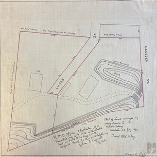
Smallest: Plan of Rhett Farm
Our tiniest map can be found as part of a small series of plats and drafts depicting Rhett Farm in 1895. The farm was located along the Ashley River next to land owned by the Charleston Library Society. In 1905, Rhett Farm was bought by the City to expand Hampton Park, but it was instead sold to the state to be used for The Citadel campus

Best Handwriting: Decimus Chartrand Barbot
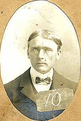
The best handwriting award goes to D.C. Barbot (1873-1934). Barbot was an architect, surveyor, and artist who served as an assistant city engineer from 1898 to 1910. He occasionally added an artistic flair to his handwriting, more often to rough drafts, showing off his talent and his interest in more than just architecture.


Municipal Map Collection (City of Charleston Records Management, Charleston, S.C.), MAP.7:23
Worst Handwriting: Louis Joseph Barbot
The worst handwriting award goes to Decimus' uncle and boss, Louis Joseph Barbot (1831-1913). Unlike his nephew, who used his drafts for his most artistic writing styles, Louis' rough drafts often left us confused. His light hand and semi-script writing leave much to be discovered within his preliminary works.

Most Likely to Have a Street Named After Them: Alfred O. Halsey (Halsey Boulevard)
In the late 1950s, many streets were getting renamed to remove duplicates, standardize spellings, and honor a few prominent Charlestonians. One of the men recognized was Alfred Olney Halsey (1872-1967), an alderman, businessman, and historian involved in civics and local politics.


Most Underrated: Eliza G. Loeb and Ethel Halsey
This category is inspired by our underdog creators, who helped the City Engineer's Office but did not get recognized for their work in an official capacity. These creators are Eliza Goldsmith Loeb and Ethel Hasley, the only women with their names on any maps in our collection.
The earlier plat shown below is of the lands of the Goldsmith and Loeb families, made in 1878 by Eliza Goldsmith Loeb (1854-1925). Eliza Goldsmith was a descendant of prominent Jewish families in Charleston who married Private Jacob H. Loeb. During the 1880s, Jacob H. "Jake" Loeb was in the cotton business for Goldsmith & Loeb. After her husband died in 1893, Eliza began operating boarding houses and was also a member of the local chapter of the National Council of Jewish Women.


Municipal Map Collection (City of Charleston Records Management, Charleston, S.C.), MAP.W10:88A
About fifty years later, in 1922. Ethel Halsey traced her plat. Ethel (1887-1972) was the younger sister of the aforementioned Alfred Olney Halsey, and a cousin of city engineer James Hervey Dingle. Additionally, Ethel was connected to Eliza Goldsmith Loeb, who was her brother's mother-in-law.
Ethel and Alfred were the children of Captain Edwin Lindsley Halsey and Maria Theresa Olney. Capt. Halsey was a wealthy Confederate captain who, with his wife, ensured his children received private educations. Ethel would marry Stephen Thomas, an architect, and remain involved in the community, arts, and civic endeavors for the remainder of her life.


Municipal Map Collection (City of Charleston Records Management, Charleston, S.C.), MAP.W6:187
Most Confusing: Compiled Plat of Charleston Neck
The map we chose for this category passed through several hands, renditions, and contains multiple notations. It mentions several plats, conveyances, and changes made from the 1740s to 1891. It is the work of at least three different surveyors over 150 years.

Biggest loss: Subway System
The collection includes some proposed projects that were never fully realized, including this plan of a subway system from 1902. This underground transit system was proposed on the heels of other cities delving into the world of subterranean and electric forms of transit. Some of the world's first subway systems include London in 1863, Chicago in 1892, Budapest and Glasgow in 1896, and Paris in 1900. In 1897, the City of Charleston passed an ordinance that would begin the subway's construction, and notes on the map state that it was approved by resolution in 1902. Unfortunately, the Committee of Streets' discussion of this topic has been lost to the sands of time, and, without much evidence, it appears that the project was quietly abandoned.


Municipal Map Collection (City of Charleston Records Management, Charleston, S.C.), MAP.W6:47
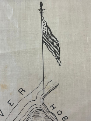
Most Memorable: Coastal Chart
One of our favorites includes this survey of the coast of South Carolina, published in 1871. The department responsible, the U.S. Coast & Geodetic Survey, was established in 1807.
The survey department was dissolved into the National Oceanic and Atmospheric Administration (NOAA) in 1970.


Municipal Map Collection (City of Charleston Records Management, Charleston, S.C.), MAP.CH:2
Best Use of Recycled Paper: Sheet Music
We've seen lots of drafts in this collection, but there's one sketch that caught our eye because of the peculiar paper that was used- sheet music! This page of sheet music with the notes filled in with pencil was co-opted by James Hervey Dingle to make a plat in a pinch in 1894. If anybody recognizes the notes of the song, we would love to know what it is!


Municipal Map Collection (City of Charleston Records Management, Charleston, S.C.), MAP.W10:36
Best Doodles: Multiple Maps
Last, but not least, we wanted to shout out our favorite doodles and details from the margins of our maps. Which one do you like best?


Municipal Map Collection (City of Charleston Records Management, Charleston, S.C.)